Maps
| Name | Description | Project | Project Type | Document Date | Town |
|---|---|---|---|---|---|
|
|
This document contains two maps - Map of Harbors, Ponds, & Ocean of MV and Map of Arterial and Collector Roads of MV. These maps are for DRI Checklist Items 5.1 & 7.1, respectively (per DRI Checklist of May 2013). This map is to assist with identifying if a proposed project falls within a geographic trigger area. If so, the user must then refer to the DRI Checklist to determine if the project must be referred to the Martha's Vineyard Commission for review. | Other | April 11, 2013 | All-Island | |
|
|
PDM Gosnold Sea Level Rise Map | Other | January 14, 2014 | Gosnold | |
|
|
Environmental Sensitivity Index Map Cuttyhunk | sensitivity of coastal environments and wildlife to spilled oil | Other | February 25, 2005 | Gosnold |
|
|
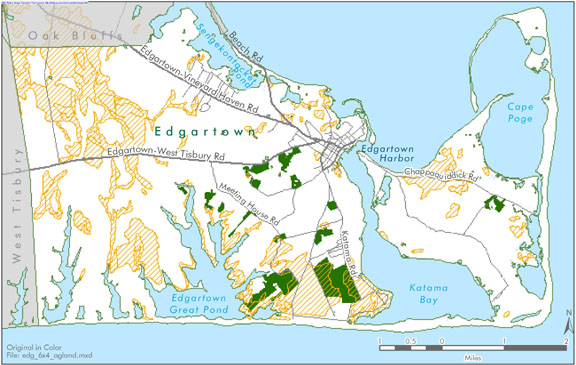
Edgartown map created for the open space and natural resources section of the Community Development Plan of 2004. | community development plan | Planning Project | October 23, 2006 | Edgartown |
|
|
Edgartown map created for the existing conditions section of the Community Development Plan of 2004. | community development plan | Planning Project | October 23, 2006 | Edgartown |
|
|
Sengekontacket Pond water quality sampling stations for resource assessment during 2005 | mv coastal pond water quality survey- summer 2005 | Planning Project | June 22, 2007 | Edgartown |
|
|
The map displays water resource assessment station in Oyster Pond where water quality samples were collected during 2007 | mv water quality survery: summer 2007 | Planning Project | June 18, 2009 | Edgartown |
|
|
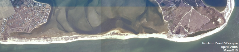
GPS collected shoreline & cliff data of Wasque point from June of 2012 overlayed on 2009 aerial photo. | wasque mapping | Planning Project | July 11, 2012 | Edgartown |
|
|
In delivering the preliminary FIRMs (Flood Insurance Rate Map), FEMA sectioned Dukes County into 68 'tiles'. This map is the index map showing the tile bounding area and corresponding index number for all the tiles within Dukes County. | Other | October 30, 2013 | Gosnold | |
|
|
Map showing suggested bike route from ferry terminals. | Other | June 25, 2014 | Oak Bluffs | |
|
|
Cape Poge Pond water quality sampling stations for water resource assessment during 2003 | mv coastal pond water quality survey- summer 2003 | Planning Project | June 15, 2005 | Edgartown |
|
|
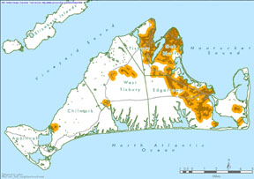
Island-wide map created for the housing section of the community development plan of 2004. | community development plan | Planning Project | October 27, 2006 | All-Island |
|
|
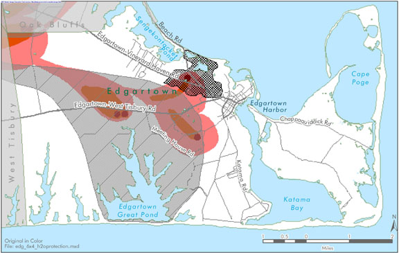
SLOSH (Sea, Lake and Overland Surges from Hurricanes) storm surge maps reflect the worst case hurricane storm surge inundation (including astronomical high tide),regardless of the point of where the center of the hurricane (or tropical storm) makes landfall. | predisaster mitigation plan | Planning Project | July 8, 2008 | All-Island |
|
|
Tidal curves for all three ponds are shown recorded over a month long survey. | Other | September 8, 2010 | All-Island | |
|
|
The map displays the water resource assessment stations in James Pond where water quality samples were collected during 2006. | mv water quality survey: summer 2006 | Planning Project | July 14, 2008 | West Tisbury |
|
|
Land use maps for the three watersheds | Other | September 8, 2010 | All-Island | |
|
|
PDM Gosnold Wildland-urban Interface Map | Other | January 14, 2014 | Gosnold | |
|
|
Environmental Sensitivity Index Map Naushon Island | sensitivity of coastal environments and wildlife to spilled oil | Planning Project | February 25, 2005 | Chilmark |
|
|
Edgartown map created for the water resources section of the Community Development Plan of 2004. | community development plan | Planning Project | October 23, 2006 | Edgartown |
|
|
Edgartown map created for the existing conditions section of the Community Development Plan of 2004. | community development plan | Planning Project | October 23, 2006 | Edgartown |
Pages
Office location:
Office location:
The Stone Building
33 New York Avenue
Oak Bluffs, MA 02557
Telephone: 508-693-3453
Fax: 508-693-7894
Mailing Address
Mailing address:
Martha's Vineyard Commission
P.O. Box 1447
Oak Bluffs, MA 02557
About the MVC
Site Map
Copyright
© 2008 - 2024
Martha's Vineyard Commission
All Rights Reserved